Hydromorphological modeling of the impact of the ALEX storm on the Vésubie and Roya river basins
- IDEX
- Research
Focus on a Géoazur research project that is taking advantage of the Azzurra cluster
Research project carried out by Rabab YASSINE and Pierre BRIGODE of the Risk team, UMR Géoazur, and by Yan JORON, student in Water Engineering at Polytech Nice Sophia.
In the Alpes-Maritimes department, torrential floods generated by significant cumulative rainfall can expose the population and infrastructures to great danger. These events are often observed in autumn, when the collision of cold air currents coming from the north and warm air currents coming from the Mediterranean occurs. In addition, the geographical location of the department, south of the Alpine chain, exposes the region to unique weather conditions when Mediterranean influences encounter the first mountains. This can lead to intense rainfall over a very short period of time, sometimes reaching 100 mm in one hour, typical of the northern regions of the Mediterranean basin.
Storm Alex which strongly impacted the Alpes-Maritimes department during the night of October 2 to 3, 2020, presented the characteristics described above. This event of impressive magnitude led to devastating floods that resulted in 10 confirmed fatalities, 8 people still missing, a hundred houses destroyed and more than 210 million euros of insured damage. The Vésubie and Roya watersheds were the most devastated by the storm, which is now considered to be the most extreme flooding phenomenon observed for at least 120 years in the Alpes-Maritimes. Several questions have emerged on the changes in the riverdbed of the different rivers, the modification of their width and the rate of sediment transport. Quantifying these processes is always a challenge for hydrologists and geomorphologists, especially in the context specific to South-East France. The use of numerical models can therefore be a real asset to understand these phenomena and help local officials choose efficient and sustainable restoration and protection solutions.
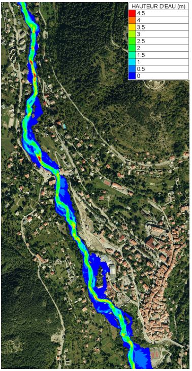
In this context, our team is using the TELEMAC2D two-dimensional numerical model to study the Boréon river (5 km), a right bank tributary of the Vésubie at Saint-Martin-Vésubie. This is one of the sectors most impacted by storm Alex. TELEMAC2D has a module that solves liquid and solid flow equations (sediment transport) on an unstructured mesh. The model can be used to simulate the water level, the average velocity and the erosion or deposition level on each mesh of the study area, and it is allowing us to make a first reconstruction of the events of October 2, 2020. The aim is to represent the overflows observed on the ground as well as the changes in the morphology of the watercourse that took place during the event, which was particularly impressive. These simulations require significant computing resources. The Azzurra cluster is providing us with the necessary resources to significantly reduce our computation time and allow us to study multiple scenarios.
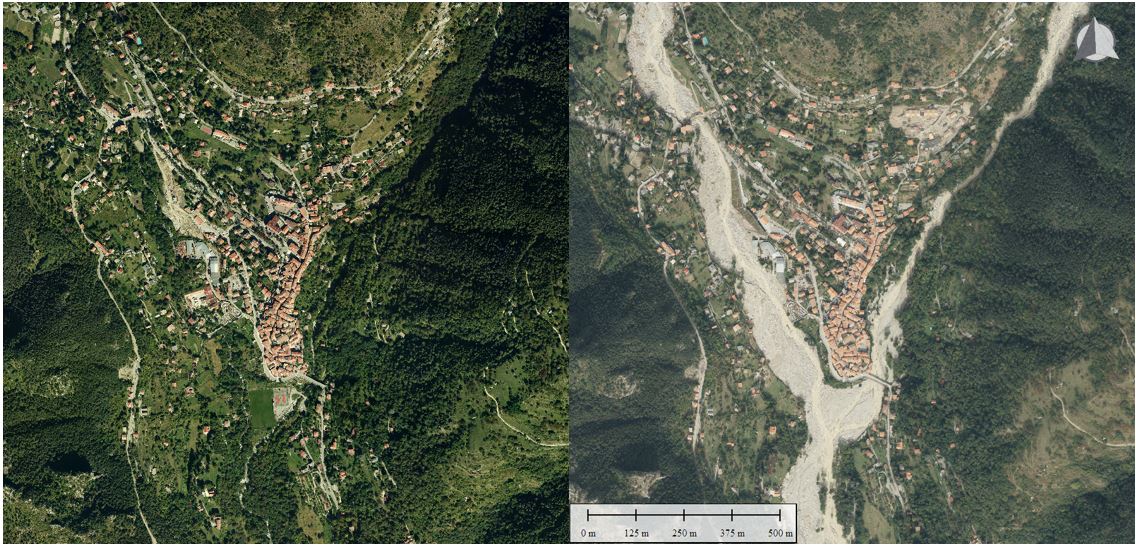
Figure 1: The Boréon at its confluence with the Vésubie in 2014 (left) and in 2020 post-Alex (right).
Figure 2 : First results of simulated water level on the Boréon river in the village of Saint-Martin-Vésubie.